O impresionantă colecție de legături spre situri care prezintă hărți este oferită pe situl Universității din Austin (Texas - USA). Cercetătorii tineri români pot găsi, cu răbdare, referințe la România.
Dan Culcer
Perry-Castañeda Library Map Collection Historical Map Web Sites
| World | Africa | Asia | Australia/Pacific | Canada | Europe |
| Mexico | Middle East | Russia | South America | United States | Astronomy |
Updated 12/19/11
Featured:The following are links to historical maps on other Web sites. Also see historical maps from our collection.
- World: Historical Maps
- American Geographical Society - Digital Map Collection
- Ancient World Mapping Center - Maps for Students
- Antique Maps (University of Florida)
- Blaeu Atlas 1659 (Universidad de Sevilla)
- Cartographical Curiosities (Yale Map Collection)
- Cartographic Images (Jim Seibold) Ancient through Renaissance. Most highly recommended
- Cartographie (Le Monde Diplomatique)
- Catalan Atlas (Bibliotheque Nationale de France)
- Classical World - Maps for Students (Ancient World Mapping Center)
- David Rumsey Collection Thousands of online historical maps and other images
- Gaihozu Digital Archive (Tohoku University Library) Maps of the areas outside Japanese Territory Prepared by Former Japanese Army
- Historical and Political Maps of the Modern Age (Joaqu�n de Salas Vara de Rey)
- Historical Atlas of the Twentieth Century (Matthew White)
- Historical Map Archive (University of Alabama)
- Historical Maps (Andras Bereznay) including Maps in Color and Black and White
- Historical Maps Online (University of Illinois)
- History of Cartography (University of Chicago Press)
- HyperHistory Online
- Hypercities Overlays historical city maps for major world cities onto Google Maps
- Images of Early Maps on the Web (Tony Campbell) including World Atlases and Maps
- Internet Historical Maps (Atlas of Cyberspaces)
- James Ford Bell Library (University of Minnesota)
- League of Nations Map 1920-1946 (Matthew White)
- Library of Congress Map Collections Online
- MapHist E-Mail Discussion Group
- Map History/History of Cartography Links (Tony Campbell)
- Mappamundi by Giovanni Leardo 1452 (American Geographical Society Library)
- Mapping History (University of Oregon)
- Maps for Historians (WWW-VL)
- MapTrade E-Mail Discussion Group - Antique Maps
- Mercator Globes (Harvard Map Collection)
- Military History Atlases (U.S. Military Academy, West Point)
- Norman B. Leventhal Map Center (Boston Public Library)
- Oddens' Bookmarks
- Ortelius - Theatrum Orbis Terrarum, 1570 (Library of Congress Geography and Map Division/American Memory) including 53 detailed maps
- Mapping History Project (University of Oregon)
- Political History Maps (Le Monde Diplomatique)
- Roman Empire 120 A.D. (NLTL)
- ShtetlSeeker - Central and Eastern Europe
- Spatial History Project (Stanford University)
- Trade Routes and Great Empires of the 1st Century A.D. (NLTL)
- The Book of Curiosities (Bodleian Library)
- World War I - Maps (Trenches on the Web)
- World War II Maps (Jozsef Attila University)
- World War II Maps - Asia/Pacific (U.S. Military Academy)
- World War II Maps - Europe (U.S. Military Academy)
- Africa: Historical Maps
- Addis Ababa, Ethiopia 1909 (American Geographical Society)
- Addis Ababa, Ethiopia 1912 (American Geographical Society)
- Africa - Historical Maps (Afriterra)
- Africa - Historical Maps (Northwestern University Libraries)
- Africa 1707 (University of Minnesota)
- Africa 1914 (Unimaps)
- Algeria and Tunisia - 1888 Maps (Profburp)
- Algeria and Tunisia - 1903 Maps (Profburp)
- Algeria and Tunisia - 1916 Maps (Profburp)
- Algeria and Tunisia - 1937 Maps (Profburp)
- Central Africa Explored 1841-1888 (UniMaps)
- Central Africa 1880's (Library of Congress Geography and Map Division/American Memory)
- Congo Crisis 1960-1964 (UniMaps)
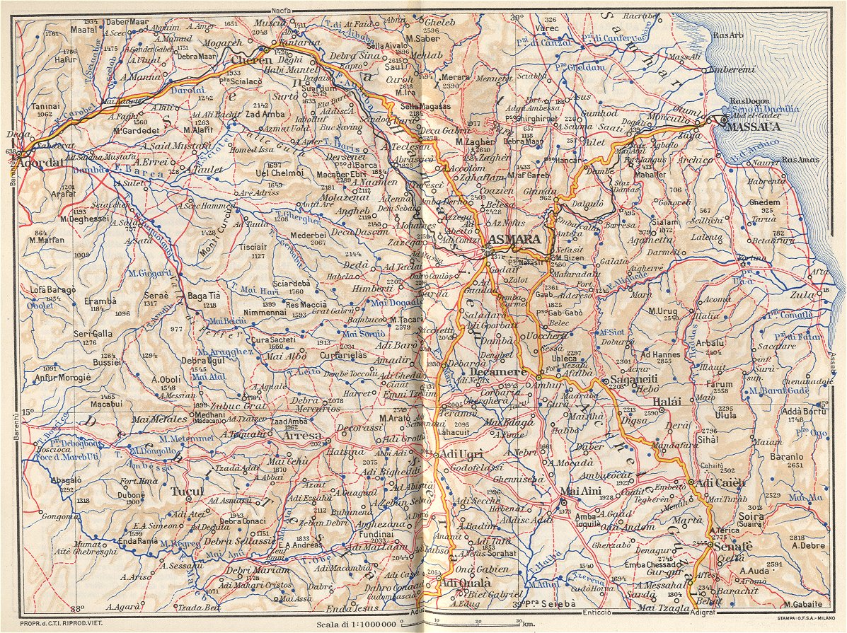
- Eritrea 1936 (TrainWeb)
- Ethiopia - James Bruce, 1769-1771 (UniMaps)
- German Cameroons 1914 (UniMaps)
- Guinea 1625 by Jodocus Hondius (University of Florida)
- Interactive Ancient Mediterranean
- Kenya 1886 (UniMaps)
- Kenya 1901 (UniMaps)
- Leopoldville 1954 [Kinshasa] (Katembo)
- Leopoldville 1960 [Kinshasa] (Katembo)
- Liberia Maps 1830-1870 (Library of Congress Geography and Map Division/American Memory)
- Luluabourg 1960 [Kananga] (Katembo)
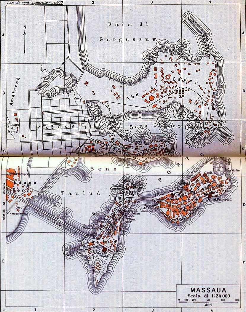
- Massawa 1936 (TrainWeb)
- Mogadishu, Somalia - Historical Maps (Rick Davies)
- Nairobi, Kenya and Environs 1970 (Survey of Kenya/Eusoils)
- Nairobi, Kenya - U.S. Embassy Bombing Map [1998] (Washington Post)
- Niger River between Tombouctou and Dounzou, Niger 1912 (American Geographical Society)
- Nyasaland, Central - Land Utilisation 1935 (Eusoils)
- South Africa 1899-1910 (UniMaps)
- Southern Africa 1747 by Emanuel Bowen (David Rumsey Collection) [Opens in new window]
- South West Africa [Namibia] 1972 (Eusoils)
- Sudan 1884-1900 (UniMaps)
- Swaziland 1966 (Eusoils)
- Tanganyika and Zanzibar 1886 (UniMaps)
- Theban Mapping Project
- West Africa 1561 Girolamo Ruscelli [Ptolemy Atlas] (University of Florida)
- West Africa 1800 (UniMaps)
- West Africa Explored 1800-1830 (UniMaps)
- West Africa 1870 (UniMaps)
- More Links to Images of Early Maps - Africa (Map History / History of Cartography Site)
- Americas
- North America - Atlantic Neptune 1777-1781 (National Maritime Museum, Greenwich)
- More Links to Images of Early Maps - Americas (Map History / History of Cartography Site)
- More Links to Images of Early Maps - North America (Map History / History of Cartography Site)
- Canada: Historical Maps
- Atlas of Canada [See History]
- Atlas of Canada - Archives (Government of Canada)
- British Columbia Archives and Records Service (Canada)
- Canada - Exploration and Settlement (Library and Archives Canada)
- Canada - Historical Maps - Archivia.net: Maps, Plans and Charts
- Canada - Historical Maps (Canadian Heritage Gallery)
- Canada - Historical Maps (Pugsley Collection/McGill University)
- Canada - Origins of the People 1901 (Fran�ois-Pierre Gingras)
- Canoe Voyages of René Menard, 1641-1660 (John S. Allen)
- Historical Atlas of Canada (University of Toronto)
- Mapping Canada 1770-1999 (Canadian Geographic)
- Newfoundland Historical Maps (Centre for Newfoundland Studies)
- Panoramic Maps of Canadian Cities (Library of Congress Geography and Map Division/American Memory)
- Territorial Evolution of Canada 1867-1999 (Natural Resources Canada)
- Tresors de la Cartotheque de l'Universite Laval
- Victoria, British Columbia 1861 (BC Archives)
- More Links to Images of Early Maps - Canada (Map History / History of Cartography Site)
- Mexico: Historical Maps
- Mesoamerica - Linguistic Areas (FAMSI)
- Mexico City - Historical Maps (Historic Cities)
- Mexico City 1524 (Mexico Channel)
- Mexico City 1550 (University of Art and Design Helsinki/UIAH, Media Lab)
- Mexico City 1597 - Sebastian M�nster (Library of Congress Geography and Map Division/American Memory)
- Mexico City 1794 (Library of Congress Geography and Map Division/American Memory)
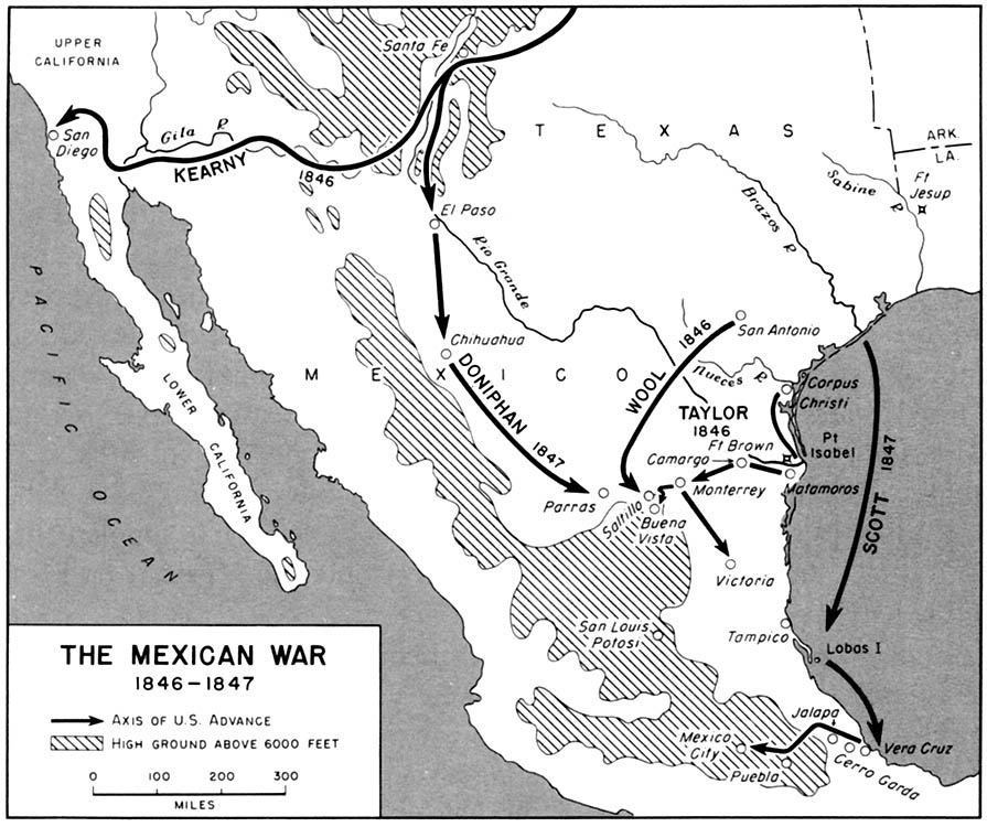
- Mexican War 1846-1847 (U.S. Army)
- Mexican War - Maps (Antonio Rafael de la Cova)
- Mexican War - Maps (U.S. Military Academy, West Point)
- Mexico - Classic Period 250 A.D. - 900 A.D. (Mexico Connect)
- Mexico - Historical Maps [click on the images] (Library of Congress Geography and Map Division/American Memory)
- Mexico - Postclassic Period 900 A.D. - 1521 A.D. (Mexico Connect)
- Mexico - Preclassic Period 2000 B.C. - 250 A.D. (Mexico Connect)
- Mexico - Relaciones Geogr�ficas (Benson Latin American Collection, University of Texas)
- Oaxaca - Linguistic Map - Time of the Spanish Conquest (Tom Penick)
- Aztec, Olmec, and Mesoamerican Maps (History Link 101)
- South and Central America, The Caribbean and Atlantic Islands: Historical Maps
- Map of America by Diego Gutierrez 1562 (Library of Congress Geography and Map Division/American Memory)
- American Revolution and Its Era: Maps and Charts of North America and the West Indies, 1750-1789 (Library of Congress Geography and Map Division/American Memory)
- Bay of Pigs 1961 (Cryptome.org)
- Bermuda 1626 [North Atlantic] (University of Minnesota)
- Colombia and Panama 1640 (University of Minnesota)
- Cusco/Cuzco - Historical Maps (Historic Cities)
- Electric Transport in Latin America [includes maps] (Allen Morrison)
- Falklands Invasion 1982 (U.S. Military Academy, West Point)
- Galapagos Islands Maps (John Woram)
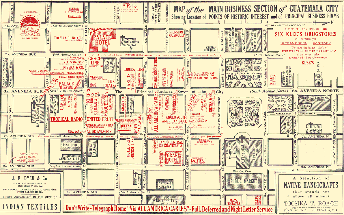
- Guatemala City circa late 1930s - Main Business District (University of California at Berkeley)
- Havana Harbor, Cuba 1790 (Library of Congress Geography and Map Division/American Memory)
- Hispaniola Map by Christopher Columbus 1492-93 (Jim Siebold)
- Latin America - Historical Maps (University of Florida)
- Netherlands Antilles and Suriname - Historical Maps (KIT Library, Royal Tropical Institute)
- Panama Invasion 1989-90 (U.S. Military Academy, West Point)
- Puerto Rico Historical Maps (Library of Congress Geography and Map Division/American Memory)
- S�o Paulo 1913 (Library of Congress Geography and Map Division/American Memory)
- Spanish-American War - Maps (RootsWeb)
- Spanish-American War - Maps (U.S. Military Academy, History Department)
- West Indies 1774 (Library of Congress Geography and Map Division/American Memory)
- West Indies - Goff's Historical Map of the Spanish-American War in the West Indies, 1898 (Library of Congress Geography and Map Division/American Memory)
- More
Links to Images of Early Maps - South & Central America, and the
West Indies (Map History / History of Cartography Site)
United States: Historical Maps
A | B | C | D | E | F | G | H | I | J | K | L | M | N | O | P | Q | R | S | T | U | V | W | X | Y | Z
- Alabama - Historical Maps (University of Alabama)
- Alabama 1818
- Alabama 1895 (LivGenMI)
- Alaska 1895 (LivGenMI)
- Alaska 1906, U.S. General Land Office (David Rumsey Collection)
- Alaska - Exxon Valdez Oil Spill, March 1989 (Explore North)
- Alaska - Exxon Valdez Oil Spill Maps (State of Alaska)
- The American Revolution and Its Era: Maps and Charts of North America and the West Indies, 1750-1789 (Library of Congress Geography and Map Division/American Memory)
- American Revolution - Atlas (U.S. Military Academy, West Point)
- Arizona 1895 (LivGenMI)
- Arizona - Ghost Towns (Ghosttowns.com)
- Arizona - Maps of the Pimar�a: Early Cartography of the Southwest (University of Arizona Library)
- Arizona and New Mexico 1925, Rand McNally (David Rumsey Collection)
- Arkansas 1875 - Asher and Adams (David Rumsey Collection)
- Arkansas 1895 (LivGenMI)
- Atlantic Neptune Online
- Baltimore 1838 Thomas Bradford (David Rumsey Collection) [Opens in new window]
- Baltimore 1885 (University of Maryland Libraries)
- Beckwourth Trail [California] (Beckwourth.org)
- Boston 1778 (Yale University Map Collection)
- Boston ca. 1800 and Map information (Earlyamerica.com)
- Boston, Massachusetts - Boston Atlas (Mapjunction.com)
- Buffalo, New York - Historical Maps (BuffaloResearch.com)
- Caddoan Languages and Peoples 17th and 18th Centuries (Texas Beyond History)
- California as an island, Louis Hennepin 1699 (University of Minnesota)
- California - Beckwourth Trail (Beckwourth.org)
- California 1873 - Bancroft's Map of California, Nevada, Utah and Arizona (UNLV Libraries)
- California 1895 (LivGenMI)
- California 1901 Southern Pacific Railway Map (David Rumsey Collection) [Opens in new window]
- California - Historical Road Maps of Southern California (Mike Ballard)
- California - Historical Topographic Maps (UC Berkeley Library)
- California - Historical Topographic Maps (California State University, Chico)
- California - Historical Topographic Maps - Southern California [.sid format] (UCSB)
- California - Historical Topographic Maps - Los Angeles (William Bowen)
- California - Historical Topographic Maps - San Diego County (SDAG)
- California - Historical Topographic Maps - San Francisco Bay Area (UC Berkeley Library)
- Census Atlases: Presenting the Nation's Cultural Geography (Library of Congress Geography and Map Division/American Memory)
- Charlestown, South Carolina Siege 1776 (earlyamerica.com)
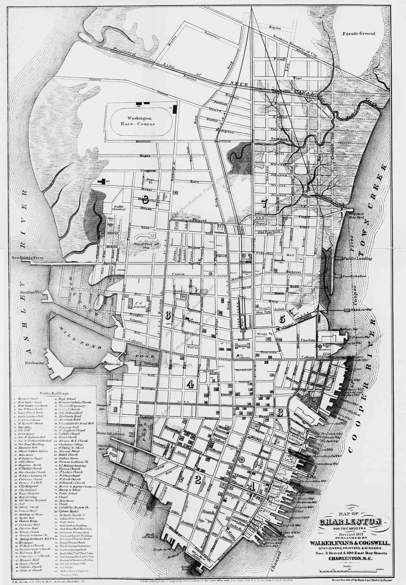
- Charleston, South Carolina 1877 (University of Georgia)
- Charlottesville, Virginia - Sanborn Fire Insurance Maps (University of Virginia Libraries)
- Chicago 1857 Rufus Blanchard [pre-fire map] (David Rumsey Collection) [Opens in new window]
- Chicago 1871 Great Fire
- Chicago 1886 Robinson's Atlas, Fire insurance maps (University of Illinois at Chicago)
- Chicago 1931 A Map of Chicago's Gangland from Authentic Sources (University of Illinois)
- Chisholm Trail (Along the Chisholm Trail)
- Civil War Atlas (U.S. Military Academy, History Department)
- Civil War Maps (Library of Congress Geography and Map Division/American Memory)
- Civil War - State Maps Showing Battle Sites
- Cleveland Historical Maps from (Cleveland Cartography/William C. Barrow)
- Colorado 1872 (Pam Rietsch)
- Colorado 1895 (LivGenMI)
- Colorado and Wyoming - Overland Trail 1862-1869 (Elizabeth Larson)
- Columbus Letter Exhibit (Univ. of Southern Maine)
- Connecticut Historical Maps (University of Connecticut Libraries)
- Connecticut - Historic Topographic Maps (My Topo)
- Connecticut - Historic Topographic Maps (University of New Hampshire)
- Connecticut - USGS Topographic Map Mash-Up (University of Connecticut)
- Connecticut 1895 (LivGenMI)
- Counties, U.S. - Historical County Lines (John Robertson)
- Delaware 1775 (Delaware Genealogical Society)
- Delaware Historical Maps (Delaware Public Archives)
- Delaware - Historical Topographic Maps (MyTopo)
- Detroit 1764 (Yale University Map Collection)
- Detroit 1873 from Atlas of the State of Michigan (David Rumsey Collection) [Opens in new window]
- Detroit 1897 Rand McNally (David Rumsey Collection) [Opens in new window]
- Early America Maps (Archiving Early America)
- European Settlements and Indian Tribes, 1750 [East Coast] (Maryland State Archives)
- Florida - Historic Florida (University of Florida)
- Florida - Historic Florida Maps (University of South Florida)
- Florida - Historical Map Collection (University of Florida)
- Florida 1895 (LivGenMI)
- Florida - Sanborn Fire Insurance Maps (University of Florida)
- Florida - Spanish Land Grant Maps (Florida State Archives)
- Fort Snelling, Minnesota 1823
- Frankfort, Kentucy 1907 - Sanborn Fire Insurance Maps (David Rumsey Collection) [opens in new window]
- Georgia and Alabama 1839 (Library of Congress Geography and Map Division/American Memory)
- Georgia 1895 (LivGenMI)
- Georgia - Historical County Boundaries (Family History 101)
- Georgia - Online Historical Maps (University of Georgia, Hargrett Library)
- Georgia - Sanborn Fire Insurance Maps (Digital Library of Georgia)
- Georgia - Spanish Missions (John Worth)
- Georgia - Sherman's March Interactive Maps (UMBC)
- Gettysburg Battlefield [Pennsylvania] (Library of Congress Geography and Map Division/American Memory)
- Great Lakes 1744 (University of Illinois)
- Hawaii 1881 (Library of Congress Geography and Map Division/American Memory)
- Hawaii - Historical Topographic Maps (University of Hawaii at Manoa)
- Hawaii - Pearl Harbor Multimedia Map (National Geographic) [Flash]
- Honolulu 1915 (American Geographical Society)
- Idaho 1895 (LivGenMI)
- Idaho, Montana, Wyoming 1937, Texaco Road Map by Rand McNally (David Rumsey Collection)
- Illinois 1895 (LivGenMI)
- Illinois - Historical Maps (University of Illinois)
- Illinois - Historical Aerial Photographs (Illinois State Geological Survey)
- Indian Land Cessions in the United States (Library of Congress Geography and Map Division/American Memory)
- Indiana 1895 (LivGenMI)
- Iowa 1895 (LivGenMI)
- Iowa 1930 - Hixson Plat Map Atlases (University of Iowa Libraries)
- Kansas 1872 (Pam Rietsch)
- Kansas 1895 (LivGenMI)
- Kansas City, Kansas 1887 from "The Official State Atlas of Kansas..." (David Rumsey Collection) [Opens in new window]
- Kentucky 1895 (LivGenMI)
- Lewis and Clark Expedition GIS (David Rumsey Collection) [Opens in new window]
- Louisiana and the Course of the Mississippi River 1720 (University of Illinois)
- Louisiana 1895 (LivGenMI)
- Louisiana - Historical Maps (Louisiana Digital Library)
- Los Angeles, California 1871 (Library of Congress Geography and Map Division/American Memory)
- Los Angeles California 1933-1939 - WPA Maps Digital Archive (USC)
- Madison, Wisconsin 1855 (Wisconsin Historical Society)
- Maine 1895 (LivGenMI)
- Maine - Historical Topographic Maps (MyTopo)
- Maine - Historic Topographic Maps (University of New Hampshire)
- Maryland 1895 (LivGenMI)
- Maryland - Historical Maps (University of Maryland Libraries)
- Maryland - Historical Topographic Maps (MyTopo)
- Massachusetts 1879 (Library of Congress Geography and Map Division/American Memory)
- Massachusetts 1895 (LivGenMI)
- Massachusetts - Historical Topographic Maps (MyTopo)
- Massachusetts - Historic Topographic Maps (University of New Hampshire)
- Massachusetts - Salem Witch Trials Maps (University of Virginia)
- Michigan 1895 (LivGenMI)
- Michigan - County Atlases
- Middle Atlantic States - American Shores: Maps of the Middle Atlantic Region to 1850 (New York Public Library)
- Military Battles and Campaigns Maps (Library of Congress Geography and Map Division/American Memory)
- Military History Atlases (U.S. Military Academy, West Point)
- Minnesota 1895 (LivGenMI)
- Mississippi 1888 (Library of Congress Geography and Map Division/American Memory)
- Mississippi 1895 (LivGenMI)
- Mississippi - Historical County Boundaries (Family History 101)
- Missouri 1895 (LivGenMI)
- Missouri - Historical Maps (St. Louis Public Library)
- Missouri - Historical Maps (Missouri Digital Heritage)
- Mitchell Map of North America - 1775 (University of Southern Maine)
- Montana - 1872 (Pam Rietsch)
- Montana 1895 (LivGenMI)
- National Parks - Mapping the National Parks (Library of Congress Geography and Map Division/American Memory)
- Native Americans - American Indians of the Pacific Northwest: Maps (University of Washington)
- Nautical Charts - Historical Nautical Charts and Maps (U.S. NOAA, Office of Coast Survey)
- Nebraska 1895 (LivGenMI)
- Nebraska 1920 - Road Map, Mid West Map Company (David Rumsey Collection)
- Nevada - Carson City Historic Places (National Park Service)
- Nevada - Ghost Towns Clickable Map (Ghosttowns.com)
- Nevada - Historical Maps (Nevada Department of Transportation)
- Nevada in Maps [Historical Maps] (University of Nevada, Reno)
- Nevada - Historical Topographic Maps (University of Nevada, Reno)
- Nevada - Reno Historic Places (National Park Service)
- Nevada - Southern Nevada and Las Vegas History in Maps (UNLV Libraries)
- Nevada - Virginia City Historic Places (National Park Service)
- Nevada 1895 (LivGenMI)
- New England - Historic Topographic Maps (University of New Hampshire)
- New England - MAGIC Historical Map Collection (University of Connecticut)
- New England - Map by William Hubbard 1677 (University of Virginia)
- New Hampshire 1895 (LivGenMI)
- New Hampshire - Historical Topographic Maps (MyTopo)
- New Hampshire - Historic Topographic Maps (University of New Hampshire)
- New Jersey 1895 (LivGenMI)
- New Jersey - Historical Maps (Rutgers)
- New Jersey - Historical Topographic Maps (MyTopo)
- New Jersey - Historical Topographic Manuscript Maps (NJDEP)
- New Mexico 1895 (LivGenMI)
- New Orleans 1885, World's Industrial And Cotton Centennial Exposition (David Rumsey Collection)
- New York - Cayuga, Seneca, Onondaga and Tompkins Counties, Historical Maps (RootsWeb/Bill Hecht)
- New York - Long Island [New York] Maps and Their Makers (SUNY Stony Brook)
- New York City - George Washington's Battle Engagements 1776 and Map information (Earlyamerica.com)
- New York City - Digital Harlem [map ca. 1930] (University of Sydney)
- New York City - September 11, 2001 Map Sites
- New York State 1895 (LivGenMI)
- New York State Historical Maps (SUNY, Stony Brook)
- New York State Historical Maps Links (SUNY, Stony Brook)
- New York State - Historical Topographic Maps (MyTopo)
- New York State - Historical Topographic Maps (University of New Hampshire)
- North Carolina - Historical Topographic Maps [JPEG 2000 format] (North Carolina State University Libraries)
- North Carolina - Maps (University of North Carolina Libraries)
- North Carolina 1895 (LivGenMI)
- North Carolina - Sanborn Maps (University of North Carolina)
- North Dakota (North part of Dakota Territory) 1888 (RootsWeb)
- North Dakota 1895 (LivGenMI)
- North Dakota and South Dakota 1937, Texaco Road Map by Rand Mcnally (David Rumsey Collection)
- Ohio 1895 (LivGenMI)
- Ohio - Historical Topographic Maps (MyTopo)
- Oklahoma and Indian Territories 1894 (Library of Congress Geography and Map Division/American Memory)
- Oklahoma 1895 (LivGenMI)
- Oklahoma - 1934 Dust Bowl Map [at bottom of page] (Oklahoma Department of Libraries)
- Oklahoma - Texas Cattle Trail (Donna Dreyer)
- Oregon 1895 (LivGenMI)
- Oregon 1935, Standard Oil Company of California Road Map (David Rumsey Collection)
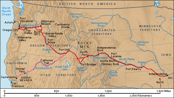
- Oregon Trail and California Trail (Yesteryearsnews)
- OSSHE Historical and Cultural Atlas Resource - North America (Requires Shockwave Plug-In)
- Panoramic Maps 1847-1929 (Library of Congress Geography and Map Division/American Memory)
- Pennsylvania 1895 (LivGenMI)
- Pennsylvania - Historical Topographic Maps (MyTopo)
- Pennsylvania - Historical Topographic Maps [downloadable] (PASDA)
- Philadelphia, Pennsylvania - PhilaPlace [1875-contemporary]
- Philadelphia, Pennsylvania - Philadelphia GeoHistory Map Viewer [1843-current]
- Philadelphia, Pennsylvania 1802 by Charles P. Varle (David Rumsey Collection) [Opens in new window]
- Philadelphia, Pennsylvania - Mapping Du Bois [Philadelphia's Seventh Ward, ca. 1899]
- Philadelphia, Pennsylvania - Redlining Maps 1936-1937 (Cartographic Modeling Laboratory)
- Pittsburgh, Pennsylvania - Historical Pittsburgh Map Collection (University of Pittsburgh)
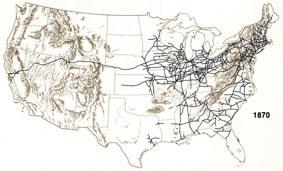
- Railroad Maps 1828-1900 (Library of Congress Geography and Map Division/American Memory)
- Railroad Maps - Central Pacific Railroad Maps (CPR Photographic History Museum)
- Railroad Maps - 1891 Grain Dealers and Shippers Gazette Maps (Pam Rietsch)
- Revolutionary War Maps (earlyamerica.com)
- Rhode Island 1895 (LivGenMI)
- Rhode Island - Historical Topographic Maps (MyTopo)
- Rhode Island - Historic Topographic Maps (University of New Hampshire)
- Route 66 - Maps (http://roadsidephotos.sabr.org/66/)
- St. Louis, Missouri - [1816-1967] The Wayman Map (Washington University) [sid Format]
- Salem, Massachusetts - Salem Witch Trials Maps (University of Virginia)
- San Francisco 1848 (zpub)
- San Francisco 1849-50 (zpub)
- San Francisco Bay 1860 (University of California at Berkeley)
- San Francisco 1897-1997 Historic Topographic Maps (University of California, Berkeley)
- San Francisco - Earthquake and Fire 1906 (University of California at Berkeley)
- San Francisco - Golden Gate International Exposition 1939 (Univ. of California at Berkeley)
- Seneca Villages and the Jesuit and French Contacts 1615-1708 and About the Map (John S. Allen)
- Sioux Wars - Atlas (U.S. Army Command and General Staff College)
- South Carolina - Historical County Boundaries (Family History 101)
- South Carolina - Sanborn Fire Insurance Maps (University of South Carolina)
- South Carolina 1895 (LivGenMI)
- South Dakota 1895 (LivGenMI)
- Tennessee 1895 (LivGenMI)
- Tennessee Historical Maps (TNGenNet)
- Texas - Historical Maps Maps from many sources
- Texas - Historical City Maps Maps from many sources
- Trail of Tears Map (National Park Service)
- United States 1798 Johann Walch (University of Illinois)
- United States Atlas 1895 (Pam Rietsch/USGenNet) Individual county maps as well as state maps
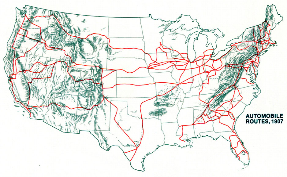
- United States - Automobile Routes 1907 (Latin American Studies.org)
- United States - Blackout - August 14, 2003 - 20 Hours Before (Air Force Weather Agency)
- United States - Blackout - August 15, 2003 - 7 Hours After (Air Force Weather Agency)
- United States - Blackout - Northeast U.S./Canada Blackout (USA Today) [requires Flash]
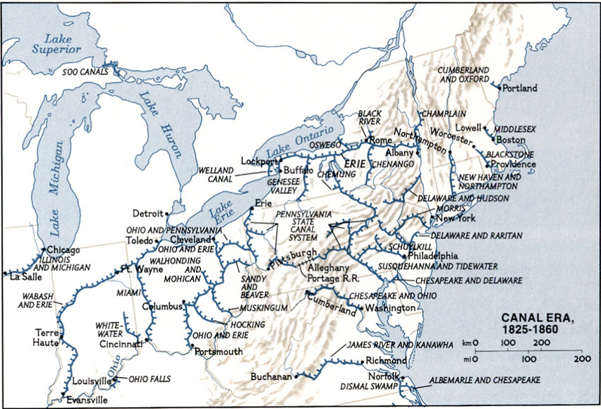
- United States - Canals 1825-1860 (Latin American Studies.org)
- United States - Census Atlases 1870, 1880, 1890 (Library of Congress Geography and Map Division/American Memory)
- United States - Historical Atlases (FamilyHistory101.com)
- United States - Historical Census Browser [maps of state and county data 1790-1960] (University of Virginia)
- United States - Historical County Boundaries (Newberry Library)
- United States - Historical County Lines Maps (John Robertson)
- United States - Historical Maps (GenWeb)
- United States 1812, Abraham Bradley (David Rumsey Collection)
- United States 1822, John Melish (David Rumsey Collection)
- United States - Malaria Deaths 1870 (Library of Congress Geography and Map Division/American Memory)
- United States - Native American Tribes 1783 (University of Oregon)
- United States - Nautical Charts, Historical (Office of Coast Survey)
- United States - Overland Routes 1860 (Latin American Studies.org)
- United States - Presidential Elections Atlas (Dave Leip)
- United States - Presidential Elections 1789-2000 (National Atlas)
- United States - Railroads 1870 (Latin American Studies.org)
- United States - Railway Atlas 1891 (Pam Rietsch)
- United States - Road Map 1947, Rand McNally (David Rumsey Collection)
- United States - Slave Crops in the American South 1860 (University of Oregon)
- United States Territorial Maps 1775-1920 (University of Virginia)
- United States - Voting Maps 1840-2008 (University of Richmond)
- University of Georgia Hargrett Library - Historical Maps
- Utah 1895 (LivGenMI)
- Utah - Sanborn Fire Insurance Maps (University of Utah)
- Virginia 1895 (LivGenMI)
- Vermont 1895 (LivGenMI)
- Vermont - Historical Topographic Maps (MyTopo)
- Vermont - Historic Topographic Maps (University of New Hampshire)
- Virginia - Historical Topographic Maps (MyTopo)
- War Of 1812 - Maps (U.S. Military Academy, West Point)
- Washington, D.C. Historical Maps (DC Pages)
- Washington, D.C. - Sniper Shootings Maps, October 2002 (Washington Post) [requires Flash]
- Washington State - Early Washington Maps (Washington State University)
- Washington State - Historical Maps (Washington Secretary of State)
- Washington State - Historical Topographic Maps (Washington State University)
- Washington State 1895 (LivGenMI)
- West Virginia 1895 (LivGenMI)
- West Virginia - Historical Topographic Maps (MyTopo)
- Western Exploration - Exploring the West from Monticello (University of Virginia Library)
- Wisconsin 1895 (LivGenMI)
- Wisconsin - Milwaukee Historical Maps (University of Wisconsin, Milwaukee)
- Wyoming and Colorado- Overland Trail 1862-1869 (Elizabeth Larson)
- Wyoming 1872 (Pam Rietsch)
- Wyoming 1895 (LivGenMI)
- Wyoming - Historical Maps (Wyoming State Archives)
- Wyoming - Yellowstone National Park 1897 (RootsWeb)
- Yellowstone National Park Maps 1878-1937 (Library of Congress Geography and Map Division/American Memory)
- More Links to Images of Early Maps - U.S. States and Regions (Map History / History of Cartography Site)
North America: Historical Maps
- Asia: Historical Maps
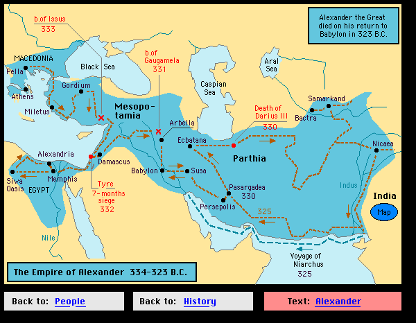
- Alexander the Great - Route (Hyperhistory.com)
- Angkor Wat, Cambodia 1926 (Univ. of California at Berkeley)
- Ashida Collection, Meiji University
- Bali - Bombings Map [October 12, 2002] (Sydney Morning Herald/Web Archive)
- Bali - Bombings Map [October 1, 2005] (Sydney Morning Herald)
- Calcutta, India 1842 (American Geographical Society)
- China - Antique Maps (HKUST Library)
- China - Civil War (U.S. Military Academy, History Department)
- Central Asia Maps (T. K. Mallon-McCorgray)
- East Indies 1598 (University of Minnesota)
- Goa 1572 (Historic Cities)
- Hanoi 1963-1965 (University of California at Berkeley)
- Harappa Site Plan (Harappa.com)
- India - Historical Atlas of South Asia (Digital South Asia Library)
- India Historical Maps (Ian Poyntz/RootsWeb)
- India - Maps from the Imperial Gazetteer of India (Digital Library of South Asia)
- Indonesia - Historical Maps 1850-1950 (KIT Library, Royal Tropical Institute)
- Indus Valley Tradition - 2600-1900 B.C. (Harappa.com)
- Japan - Historical Maps (East Asian Library, University of California, Berkeley)
- Japan - Maps "Samurai Age" (Sonobe Souan)
- Japan - World War II Firebombing Targets Map (B-29s over Korea)
- Korea - Sea of Korea Map Collection (University of Southern California)
- Korean War Maps (Korean War Project)
- Korean War Maps (U.S. Army Center of Military History)
- Korean War Maps (U.S. Military Academy, West Point)
- Macau Historical Maps (Library of Congress Geography and Map Division)
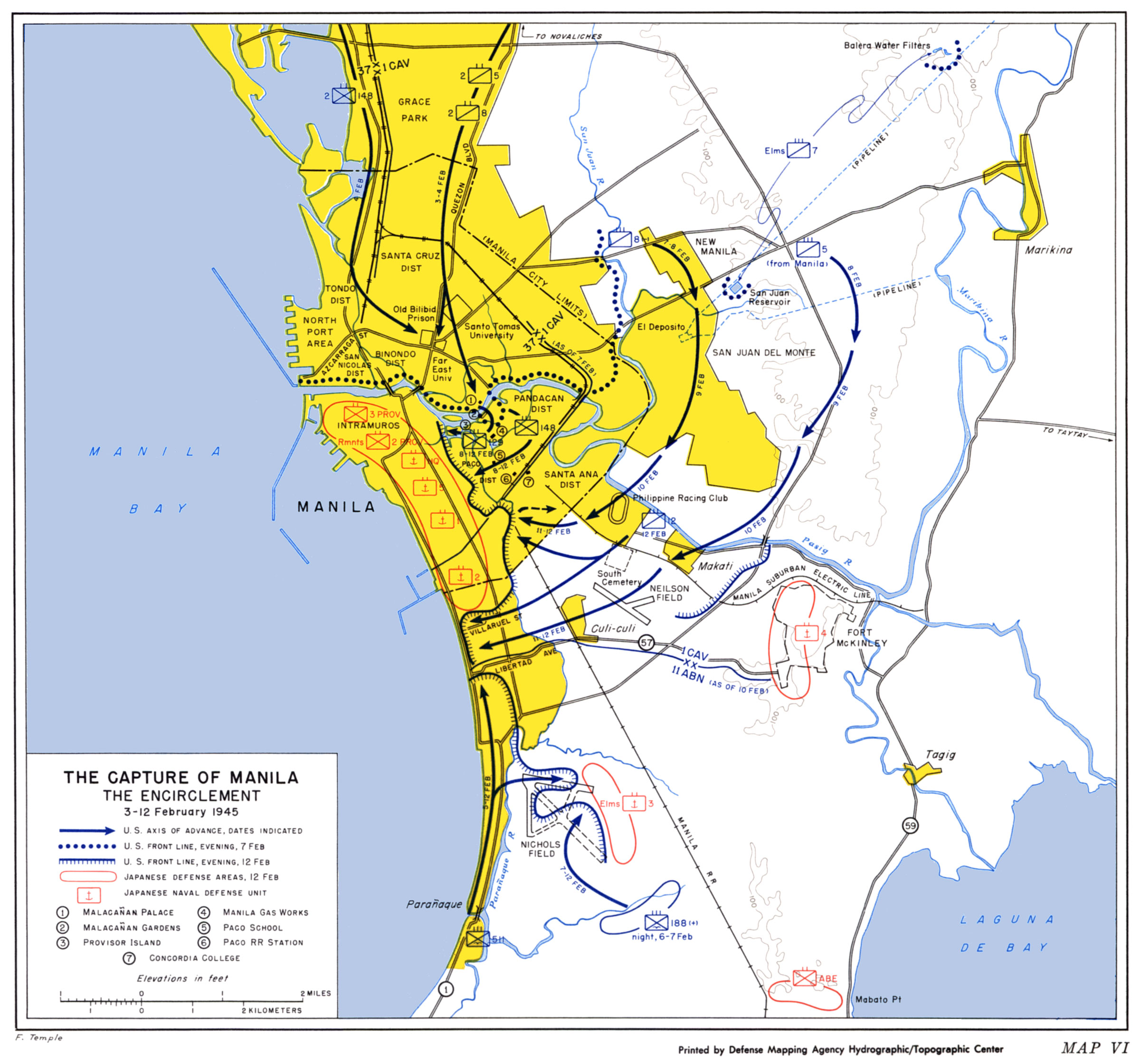
- Manila 1945 - Capture of Manila (U.S. Army, Center of Military History)
- Mongol Empire in 1227 (National Geographic)
- Mongolia - Manuscript Maps, 19th and 20th Centuries (Kamimura Akira)
- Philippines - Maps of Clark Air Base and The Philippines (Wagner High School Alumni)
- Shanghai Historical Maps [low resolution] (Institut d'Asie Orientale, Lyon)
- Shanghai - Historical Maps (Tales of Old Shanghai)
- Shanghai International Settlement (Phil Abbey/Internet Archive)
- Silk Road Atlas (ECAI)
- Silk Road Atlas (University of Washington)
- South Asia - Historical Atlas of South Asia (Digital South Asia Library)
- Taiwan - Dispersal of Formosan Aborigines in Taiwan (Paul Li/ECAI)
- Tibet 1897 (University of California at Berkeley)
- Tokyo (Edo) Interactive Map [in Japanese] (Yahoo Japan)
- Vietnam War - Detailed Maps of Cambodia, Laos, Thailand, North and South Vietnam (Jim Henthorn)
- Vietnam War - Bien Hoa/Long Binh Map (Ray Smith)
- Vietnam War Maps (U.S. Military Academy, West Point)
- Vietnam War - Topographic Maps of Vietnam (Ray Smith)
- World War II in Asia - Maps (U.S. Military Academy, West Point)
- More Links to Images of Early Maps - Asia (Map History / History of Cartography Site)
- Australia and the Pacific: Historical Maps
- Central Pacific - World War II Battles (Enterprise CV-6)
- Eastern Polynesia, 1866 (http://www.trussel.com/kir/mornstar.htm)
- Guadalcanal Battles 1942 (LemaireSoft)
- Pacific Naval Battles in World War II
- Papeete, Tahiti, French Polynesia - 1920 Nautical Chart (Univ. of Calfornia at Berkeley)
- Solomon Islands - World War II Battles (Enterprise CV-6)
- Western Pacific - World War II Battles (Enterprise CV-6)
- World War II in Asia/Pacific (U.S. Military Academy, West Point)
- More Links to Images of Early Maps - Australia & Oceania (Map History / History of Cartography Site)
- Europe: Historical Maps
- Anglo-Saxon England - Maps (Anglo-Saxons.net)
- Austria-Hungary 1910 - Topographic Maps (Zentai L�szl�)
- Balkans - Albanian Vilayets During the Ottoman Empire ca. 1878 (Kosova Information Centre)
- Balkans - History File: Yugoslavia and the Balkans (BBC)
- Balkans - Historical and Political Maps of the Balkan States (Joaquin de Salas Vara de Rey)
- Balkans - 1914 (World War I: Trenches on the Web)
- Balkans - 1918-1938 (Joaquin de Salas Vara de Rey)
- Bavaria 1789 (Thomas H�ckmann)
- Belgium - Second World War Military Mapping (National Library of Scotland)
- Berlin 1880-98 [with street index] (Historical-Geographical Encyclopedia)
- Berlin Wall Maps (Berlin Wall Online)
- Birmingham, England - 19th Century
- Blaeu's 1652 Dutch Atlas (Web Archive)
- Celts and Romans (Nigel Cross)
- Channel Islands - Old Maps
- Classical World - Maps for Students (Ancient World Mapping Center)
- Dutch Cartographers - Historic Maps
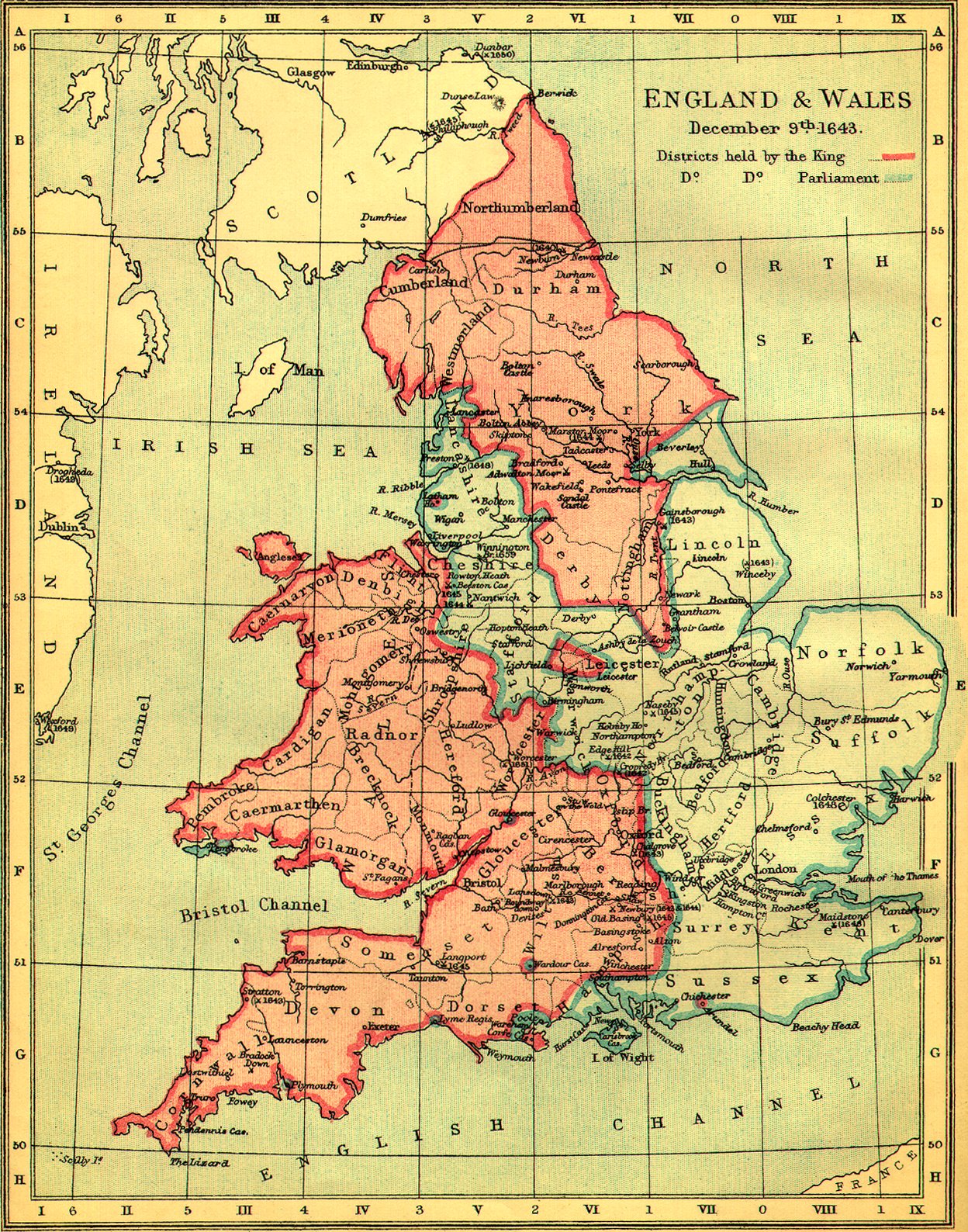
- England and Wales 1643 (GEN UKI)
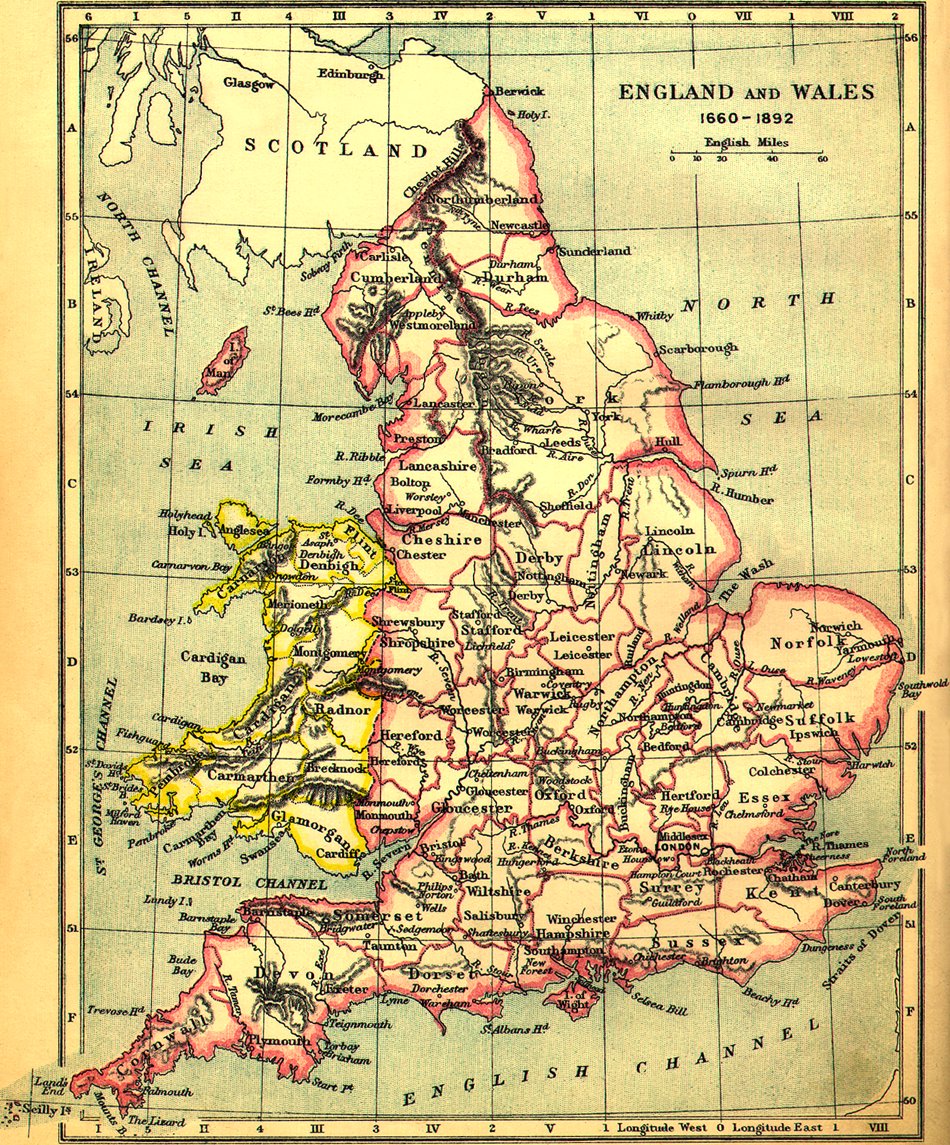
- England and Wales 1660-1892 (GEN UKI)
- Europe - Concentration Camps (About.com)
- Europe - Gardiner's Atlas of English History, 1892 (MIGenWeb)
- Europe Historical Atlas 1-2000 (Christos N�ssli)
- Europe - Historical City Maps (Historic Cities)
- Europe Historical Maps (Europe 66)
- Europe - Historical Maps (Mapping History)
- Europe Historical Maps (University of Amsterdam Library)
- Europe Historical Maps AD 1 - 1500 (De Imperatoribus Romanis)
- Europe AD 1 to AD 2000 - Maps (Periodical Historical Atlas)
- Europe - Revolutionary Europe 1806-1808 (Joaquin de Salas Vara de Rey )
- Europe - Maps 1880-1898 (Historical-Geographical Encyclopedia)
- Europe 1898 (Library of Congress Geography and Map Division/American Memory)
- Europe 1937 (Matthew White)
- Europe - Fascist Europe 1941-1945 (Joaquin de Salas Vara de Rey)
- Europe 1951-1997 - Development of the European Union (EUROCIS)
- Europe - Historical Road Maps (Landkartenarchiv)
- Finland - Maps of Finnish Cities, 1902 (Paul Kruhse)
- Florence - Della Catena Map of Florence, ca. 1471-82 (Scholarly Technology Group, Brown University)
- Florence - Historical Maps (Historic Cities)
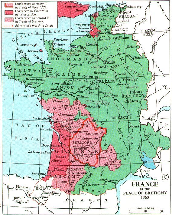
- France 1360 (Fordham)
- France 1429 (Fordham)
- France Late 15th Century (Fordham)
- France - 2005 Riots, October-November 2005 (BBC News)
- France - 2005 Riots, October-November 2005 (The Economist)
- Germany - 1789 Maps (Thomas H�ckmann)
- Germany - 1883 - Atlas of the German Empire (University of Wisconsin)
- German Expansion 1936-1939 (U.S. Military Academy, West Point)
- Germany - Historical Maps (Germany GenWeb Project)
- Germany - Historical Road Maps (Landkartenarchiv)
- Glasgow 1878 (Wikimedia)
- Granada, Spain 1598 (Historic Cities)
- Great Britain - Gardiner's Atlas of English History, 1892 (MIGenWeb)
- Great Britain - Medieval Maps
- Great Britain - John Speed Atlas 1611 (Occidental College)
- Great Britain 1940s Clickable Topographic Map (New Popular Edition Maps)
- Great Yarmouth, England 1797
- Greece, Ancient (Bernard Suzanne)
- Iceland - Antique Maps of Iceland (Randburg)
- Interactive Ancient Mediterranean
- Ireland - Historical Mapping Archive (Ordnance Survey Ireland)
- Ireland Historical Maps (Ireland's History in Maps)
- Geo Web (Biblioteca Nazionale Marciana di Venezia)
- Italy - 15th and Early 16th Centuries (Fordham)
- Italy - Napoleonic Cartography (Queen's University at Kingston, Canada)
- Lisbon, Portugal 1572 (Historic Cities)
- London: A Life in Maps Exhibit (British Library)
- London - Historical Maps (MAPCO)
- London - Historical Maps (Motco)
- London - Historical Maps (Locating London)
- London - Historical Maps (VictorianLondon.org)
- London 190 A.D. (MAPCO)
- London 1560 (Historic Cities)
- London 1666 (MAPCO)
- London 1827 - Greenwood's Map of London (Mark Annand)
- London 1856 Water Works (UCLA Department of Epidemiology)
- London 1859 - Detailed Street Map (UCLA Department of Epidemiology)
- London - 1878 Geological Street Map (MAPCO)
- London - 1889 Poverty Map (Charles Booth Online Archive/London School of Economics)
- London ca. 1922 - Pocket Atlas and Guide to London (Jonathan Hipkiss)
- Malta 1844 (Mitidja.free.fr)
- Mediterranean (Interactive Ancient Mediterranean)
- Naples, Italy - Historical Maps (Historic Cities)
- Napoleonic Wars - Maps (U.S. Military Academy, West Point)
- Netherlands - WHKMLA Historical Atlas
- Ortelius - Theatrum Orbis Terrarum, 1570 (Library of Congress Geography and Map Division/American Memory) including 53 detailed maps
- Paris, France 1550 (Historic Cities)
- Paris, France 1572 (Historic Cities)
- Paris, France 1880-98 [with street index] (Historical-Geographical Encyclopedia)
- Paris, France 1940 (Landkartenarchiv)
- Paris, France - 200 Year Tour of Gastronomic Paris (New York Times)
- Poland Historical Maps (Polish Museum, Rapperswil, Switzerland)
- Roman Empire (Interactive Ancient Mediterranean)
- Roman Empire 120 A.D. (NLTL)
- Roman Empire Battle Maps (De Imperatoribus Romanis)
- Roman Empire Maps (De Imperatoribus Romanis)
- Roman Empire - Roman Atlas (University of Kansas)
- Rome - Aquae Urbis Romae - Hydrological history and urban development (University of Virginia)
- Rome - 18th Century - Imago Urbis: Giuseppe Vasi�s Grand Tour of Rome (University of Oregon)
- Rome - Historical Maps (Historic Cities)
- Rome - The Interactive Nolli Map Website (University of Oregon)
- Scotland - Historical Map Overlays (National Library of Scotland)
- Scotland - Historical Maps (National Library of Scotland)
- Scotland - Ordnance Survey Maps 1892-1960 (National Library of Scotland)
- Spain - Galicia Oil Spill 2002 (Guardian Unlimited) [requires Flash]
- Spain - Iberian Peninsula 1270-1492 (Fordham)
- Toledo, Spain 1598 (Historic Cities)
- Viking Routes (University of Oregon)
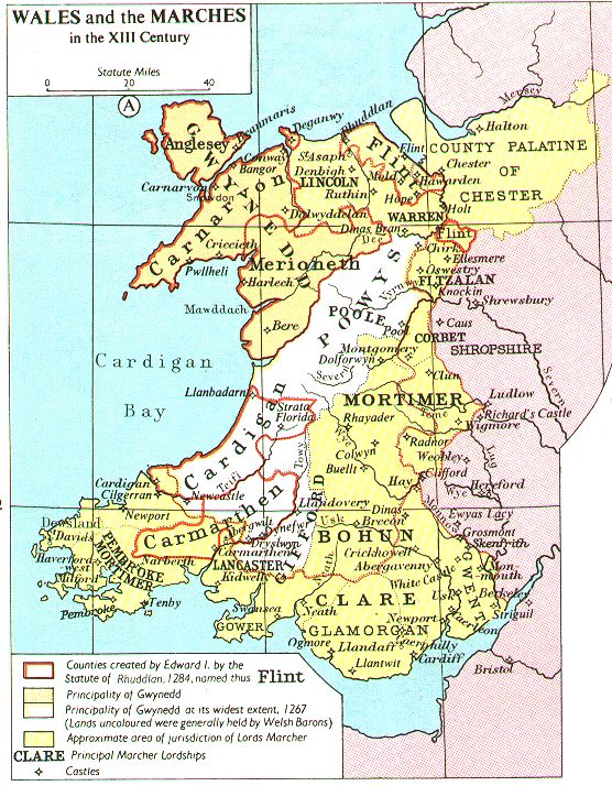
- Wales 13th Century (Fordham)
- Wales - Emigration from Wales to America (Data Wales)
- Wales - Significant Places in 19th Century Industrial Development (Data Wales)
- World War I - Maps (U.S. Military Academy, West Point)
- World War II in Europe - Maps (U.S. Military Academy, West Point)
- Yugoslavia and the Balkans - History Maps (BBC News)
- Zurich 1880-98 [with street index] (Historical-Geographical Encyclopedia)
- More Links to Images of Early Maps - Europe (Map History / History of Cartography Site)
- Middle East: Historical Maps
- Aden 1572 (Historic Cities)
- Ancient Near East Maps (About.com)
- Ancient Near East Maps Series (Oriental Institute)
- Arab-Israeli Wars - Maps (U.S. Military Academy, West Point)
- Arabia - Mapping Arabia (Saudi Aramco World)
- Asia Minor/Near East circa 150 BC (T. K. Mallon-McCorgray)
- Asia Minor and the Middle East - 1511-1774 (Walker Collection, University of Melbourne)
- Babylon Map
- Beirut Historical Maps (Michael Davie)
- Bible Maps (Blueletter)
- Bible Maps (Interactive Bible)
- Bible Maps (Signposts)
- Biblical Lands - Madaba Mosaic Map
- Cairo - Historic Maps (ICMC/Internet Archive)
- Crusader States c.1100 (Fordham)
- Giza Plateau Mapping Project (Oriental Institute)
- Gulf War Maps (PBS)
- Herat, Afghanistan 1880 (American Geographical Society)
- Holy Land - Historical Maps (University of Florida)
- Holy Land Maps (Jewish National and University Library)
- Holy Land - Zucker Holy Land Travel Manuscript Maps, 1600s (University of Pennsylvania Libraries)
- Interactive Ancient Mediterranean
- Iraq 1914 (UniMaps)
- Iraq 1918 (UniMaps)
- Iraq 1923 (UniMaps)
- Islamic Middle East - Historical Maps (Princeton)
- Israel and the Palestinians - Key Maps (BBC News)
- Israel - Atlas of Israel (Jerusalem Post) [Flash]
- Israel - Evolution of Israel (Globalsecurity.org)
- Israel - 1949 Armistice Line (BBC News)
- Jerusalem - Ancient Maps (Jewish National and University Library)
- Jerusalem in Old Maps and Views (Israel Ministry of Foreign Affairs)
- Jerusalem 1660's - Nicolaes Visscher (Library of Congress Geography and Map Division/American Memory)
- Jerusalem 1924 (University of California at Berkeley)
- Jordan and Palestine 1914 (UniMaps)
- Kandahar, Afghanistan 1880 (American Geographical Society)
- Karnak (PlanetWare)
- Lebanon 1914 (UniMaps)
- Lebanon - Line of Withdrawal of Israeli Forces from Lebanon, June 2000 (United Nations) [PDF format]
- Luxor and Karnak [two maps] (ETH-Bibliothek)
- Mesopotamia, Ancient (Oriental Institute, Univ. of Chicago)
- Middle East Historical Maps (Dartmouth University)
- Middle East 1914 (Le Monde Diplomatique)
- Middle East 1914 (UniMaps)
- Middle East 1939 (Le Monde Diplomatique)
- Nippur Site Map (Oriental Institute, Univ. of Chicago)
- Ottoman Empire 1566 (Bartleby.com)
- Palestine 1720 - Carte de la Terre Promise (Library of Congress Geography and Map Division/American Memory)
- Palestine - Maps (Miftah.org)
- Palestine - Maps (PalestineRemembered)
- Palestine - Question of Palestine Maps [1936-Present] (UNISPAL)
- Parthia Maps (Parthia.Com)
- Parthia Maps (Smithsonian)
- Sasanian Empire - Map of Mints (T. K. Mallon-McCorgray)
- Saudi Arabia 1914 (UniMaps)
- Saudi Arabia 1923 (UniMaps)
- Syria 1914 (UniMaps)
- Syria and Lebanon 1918 (UniMaps)
- Syria and Lebanon 1923 (UniMaps)
- Tel Aviv - Suicide Bombings 2000-2005 (Auscillate)
- Theban Mapping Project
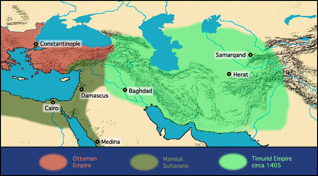
- Timurid Empire 1405 (University of Washington)
- Trans-Arabian Pipeline 1951 (Tapline)
- Walker Collection - Early Maps of Asia Minor/Middle East (University of Melbourne)
- West Bank including Jenin Refugee Camp, April 10, 2002 (Washington Post)
- West Bank, April 3, 2002 (Washington Post)
- Russia and the Former Soviet Republics: Historical Maps
- Moscow 1575 (Historic Cities)
- Moscow 1662 (Historic Cities)
- Moscow - Kremlin 1663 (Historic Cities)
- Moscow 1695 (Historic Cities)
- Moscow 1824 (Historic Cities)
- Moscow 1880-98 [with street index] (Historical-Geographical Encyclopedia)
- Moscow - Central 1975 (Univ. of California at Berkeley)
- Moscow - Theater Map, 2002 Terrorism Incident (New York Times)
- Odessa, Ukraine - Clickable Historical Map
- Russia 1723 (University of Minnesota)
- Russia and Other Historical Maps [in Russian] (Vladimir V. Nikolaev)
- Sevastopol 1855 (Wikimedia)
- St. Petersburg 1737 (Historic Cities)
- St. Petersburg 1753 (Historic Cities)
- Astronomy: Historical Maps
- Celestial Atlas 1826 (Museum of Communication, Berne)
- [Heaven and Earth Online Exhibition] Ciel & Terre (Biblioth�que Nationale de France)
- Historical Celestial Atlases on the Web (Robert Harry van Gent)
- Historical Solar Eclipse Maps (Eclipse-Maps.com)
- History of Astronomy - Map Links
- Out of This World: The Golden Age of the Celestial Atlas (Linda Hall Library)
- More Celestial Map Links (Map History/History of Cartography Site)

![Leopoldville 1954 [Kinshasa] (Katembo)](http://www.katembo.be/cartes/carte_leopoldville_1954.jpg)
![Leopoldville 1960 [Kinshasa] (Katembo)](http://www.katembo.be/cartes/PlanLeoC.jpg)
![Luluabourg 1960 [Kananga] (Katembo)](http://www.katembo.be/cartes/PlanLuluabourg.jpg)
![South West Africa [Namibia] 1972 (Eusoils)](http://eusoils.jrc.it/esdb_archive/EuDASM/Africa/images/maps/download/afr_nsw.jpg)
![West Africa 1561 Girolamo Ruscelli [Ptolemy Atlas] (University of Florida)](http://www.uflib.ufl.edu/maps/ALW0982L.JPG)
![European Settlements and Indian Tribes, 1750 [East Coast] (Maryland State Archives)](http://www.msa.md.gov/ecp/10/214/images/00200001.gif)
![Bali - Bombings Map [October 1, 2005] (Sydney Morning Herald)](http://www.smh.com.au/ffxmedia/2005/10/02/03web_bali.jpg)
Niciun comentariu:
Trimiteți un comentariu